In summary:
- Driving Iceland’s F-roads is less about 4×4 skill and more about respecting volatile natural forces like volcanic ash, geothermal vents, and glacial rivers.
- Standard car insurance is insufficient; specific Sand and Ash (SAAP) protection is non-negotiable to avoid catastrophic repair bills.
- Always trust official sources like road.is and safetravel.is over general navigation apps, as conditions can change in minutes.
- River crossings are the most dangerous part. Never cross without checking the depth first, and know your vehicle’s limits.
- Preparation is everything: pack for sudden storms, carry emergency supplies, and understand that some areas have zero cell service.
The dream of driving through Iceland’s highlands is a powerful one: vast, untouched landscapes, raw volcanic textures, and a profound sense of solitude. For many adventurers, renting a 4×4 and tackling the infamous F-roads is the ultimate way to experience this geological wonderland. The common advice is predictable: get a capable vehicle, check the weather, and be careful. But this checklist barely scratches the surface of what’s truly required.
The reality is that F-road safety has little to do with your driving skill and everything to do with understanding and respecting the elemental forces at play. These are not simply unpaved roads; they are dynamic environments shaped by volcanic activity, glacial melt, and ferociously unpredictable weather. The biggest mistakes beginners make don’t come from a lack of driving prowess, but from underestimating the power of the landscape itself. Forgetting this can lead to situations that are not just expensive, but life-threatening.
So, what if the key to a safe F-road trip wasn’t just in the ‘how’ but in the ‘why’? This guide moves beyond generic tips to explain the specific, often invisible, dangers of the Icelandic highlands. We will explore why standard insurance fails, how to read the subtle warnings of the terrain, and what it truly means to be prepared for a journey where nature, not the driver, is always in control.
This article breaks down the critical knowledge you need, from understanding hidden geological hazards to packing for a 15-minute storm. Follow along as we dissect the real challenges of Iceland’s interior to ensure your adventure is memorable for all the right reasons.
Summary: A Beginner’s Guide to Driving Safely on Iceland’s F-Roads
- Why Does Standard Insurance Not Cover Ash or Sand Damage?
- The Steam Vent Mistake That Burns Tourists Every Year
- Why Is Stepping on Icelandic Moss a Crime Against Nature?
- September or January: Which Month Is Best for Aurora Hunting?
- How to Hike to Glymur Without Getting Wet Feet?
- How to Pack for the Pyrenees Where Storms Hit in 15 Minutes?
- Why Brittany’s Granite Is Pink and Rare on a Global Scale?
- When to Be in the Forest to See the Light Transform the Landscape?
Why Does Standard Insurance Not Cover Ash or Sand Damage?
Standard car insurance policies are designed for predictable risks like collisions and theft. They are not built to handle the unique, highly abrasive power of an Icelandic sand or ash storm. These are not gentle dustings; they are high-velocity barrages of volcanic particles that act like sandpaper on a car’s exterior. In a matter of minutes, a storm can strip paint, etch glass, and destroy headlights, leading to astronomical repair bills. One analysis shows that repair costs for sand and ash damage can range between 500,000 ISK to 1,500,000 ISK, a cost that falls entirely on the driver without specific coverage.
This is why rental companies offer Sand and Ash Protection (SAAP) as a separate waiver. It’s not an upsell; it’s a financial shield against a very real and prevalent threat, especially on the south coast and in the highlands where vast volcanic sand plains (sandurs) are common. Refusing this coverage is one of the biggest gambles a visitor can take.
Case Study: The 2022 Sandstorm Incident
In 2022, a rental car caught in a sudden south-coast sandstorm highlighted the immense risk. The vehicle’s paint was stripped down to the metal on the windward side, and all plastic trim and lights were severely pitted. The damage was so extensive that the repair costs ran into the thousands of euros. As a report on the incident noted, if the driver had invested in volcanic ash insurance, they would have walked away without paying a cent for the repairs.
Prevention is as crucial as protection. Before setting out, always check the weather forecast on road.is and vedur.is for specific “Blowing Sand” warnings. If a storm is predicted, the safest action is to seek shelter in the nearest town and wait it out. Do not attempt to drive through it. If you are caught, try to park the vehicle facing away from the wind to protect the most vulnerable front-end components and wait for conditions to improve.
The Steam Vent Mistake That Burns Tourists Every Year
The most common mistake tourists make near geothermal areas is assuming that all ground is solid and all steam is harmless. In Iceland, the earth is alive, and its colorful crust can be dangerously thin and brittle. Every year, people suffer severe burns by stepping through a thin layer of soil directly into boiling mud or superheated steam just beneath the surface. This happens because they stray from marked paths, drawn by the allure of a bubbling mud pot or a hissing fumarole.
The ground in these active zones is a fragile shell of silica and clay deposits over a network of underground plumbing. The water in these geothermal mud pools is not just hot; a travel safety guide warns it can reach temperatures of up to 100°C (212°F). Falling into this is instantly catastrophic. Ropes, boardwalks, and warning signs are not suggestions; they are critical safety barriers that mark the boundary between a fascinating spectacle and a medical emergency.

The vibrant yellow, red, and white colors you see are sulfur and other mineral deposits, indicating intense heat and chemical activity right below your feet. Treat all ground in a geothermal area as potentially unstable. The beautiful, steaming landscape is a direct display of the immense and dangerous power just centimeters below the surface. Always stay on designated trails and respect every single barrier.
Why Is Stepping on Icelandic Moss a Crime Against Nature?
The lush, green, almost alien-looking moss that carpets Iceland’s lava fields is one of its most iconic natural features. It’s also one of its most fragile. This is not like the grass in a city park; it’s a delicate, slow-growing organism that can take a century or more to recover from a single footstep or tire track. Driving or walking on it causes damage that can remain visible for generations, scarring the pristine landscape.
The reason for this vulnerability lies in its structure and environment. The moss has shallow roots and grows on porous lava rock, which offers little stability. Once compressed or torn, it has no soil to re-root in and must start its growth process all over again—a process that is painfully slow in Iceland’s harsh climate. This ecological fragility is why damaging it is taken so seriously. As one F-road safety guide powerfully states:
Crushing a patch of 100-year-old moss with your car tire is the ecological equivalent of smashing a stained-glass window in a medieval cathedral.
– Environmental comparison from article content, Practical F-road safety guidance
Respecting the moss is a core tenet of responsible travel in Iceland. When driving on F-roads, this means never, ever driving off the marked track, not even for a moment to take a photo or let another car pass. Use only designated pull-outs. When on foot, stay on established trails. The “leave no trace” principle is a legal and moral obligation here, and protecting this ancient, delicate ecosystem is every visitor’s responsibility.
September or January: Which Month Is Best for Aurora Hunting?
Choosing between September and January for aurora hunting on the F-roads presents a fundamental conflict: the best conditions for the Northern Lights are often the worst and most dangerous conditions for highland driving. While January offers longer, darker nights and peak aurora activity, it comes with a critical drawback: all F-roads are completely closed and impassable due to extreme snow, ice, and brutal weather. Attempting to access them would be impossible and illegal.
September, on the other hand, offers a compelling compromise. The nights are dark enough for good aurora viewing, and most F-roads are still open, providing access to remote, light-pollution-free locations in the highlands. However, it’s a transitional month. The first snows can fall, and late-season glacial melt can keep river levels dangerously high. A guide to F-road travel notes that July through early September is the optimal time for driving F-roads, meaning late September is already pushing the limits of the safe season.
This table clearly illustrates the trade-offs involved:
| Factor | September | January |
|---|---|---|
| F-road Access | Open (most roads) | Completely closed |
| Aurora Intensity | Moderate activity | Peak activity |
| Daylight Hours | 12-13 hours | 4-5 hours |
| Main Challenges | First snowfalls, high rivers from late melt | Extreme cold, icy roads, risk of being snowed in |
| Viewing Locations | Highland F-roads with pristine dark skies | Limited to Ring Road spots (more crowded) |
For a beginner focused on F-roads, the answer is clear: September is the only viable option of the two. January aurora hunting must be confined to the main Ring Road and other accessible routes. If your primary goal is to combine F-road exploration with a chance to see the aurora, early to mid-September is your narrow window of opportunity, but you must be prepared for rapidly deteriorating conditions.
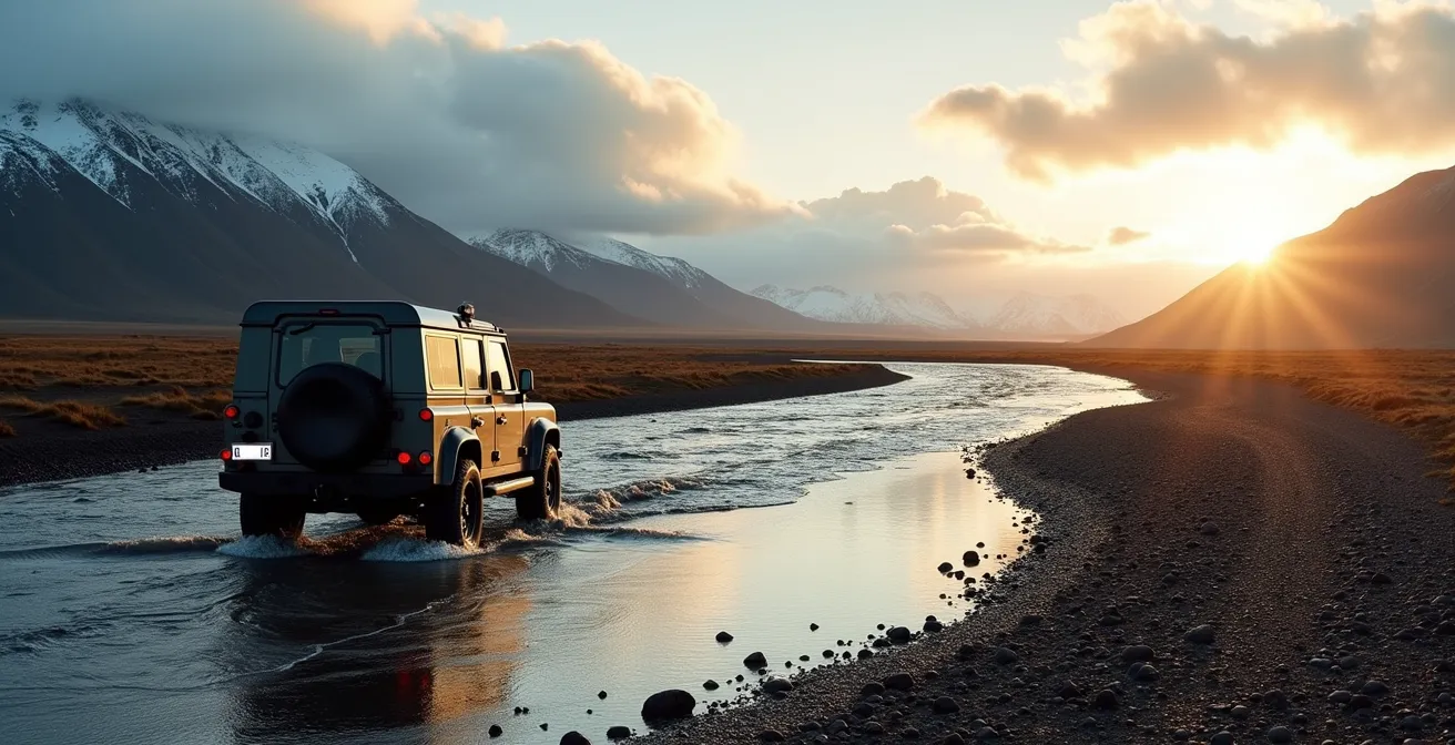
How to Hike to Glymur Without Getting Wet Feet?
The hike to Glymur, Iceland’s second-tallest waterfall, involves a famous river crossing that changes with the seasons. To cross the river Botnsá without getting wet feet during the summer months (typically June to September), hikers must use a log and a wire rope installed by the local trail maintenance teams. This makeshift bridge is the key. If you are hiking outside of this period, the log is removed for safety reasons, and you will have no choice but to wade through the cold river, making wet feet inevitable.
However, this specific trail feature is a luxury you will not find on F-road river crossings. F-road “fords” are entirely natural and require your vehicle to drive through the water. This is arguably the most dangerous part of any highland journey. The technique is critical:
- Walk the river first: Before even thinking about driving across, get out and wade through the proposed path to check the depth and current speed. If the water goes above your knees, it may be too deep for your vehicle.
- Assess the vehicle’s limits: Know your rental’s maximum wading depth. Standard 4x4s can often handle 50-70 cm, but you must confirm this. Never guess.
- Drive at an angle downstream: Enter the river slowly, pointing your vehicle slightly downstream (at about a 45° angle). This creates a “bow wave” and helps keep water away from your engine’s air intake.
- Maintain a steady speed: Use a low gear (1st or 2nd) and maintain a slow, steady pace of around 5-10 km/h. Do not stop, change gears, or lift your foot off the accelerator mid-river. Hesitation can cause you to get stuck or stall the engine.
Once you are safely on the other side, the procedure isn’t over. A critical safety check is required to ensure your vehicle is still road-worthy. This post-crossing audit is non-negotiable.
Your Post-River Crossing Safety Checklist
- Stop immediately: Pull over in a safe spot right after the crossing to perform a visual inspection of the vehicle.
- Check for parts: Verify your license plate is still attached. They are notoriously easy to lose in deep or fast-flowing water.
- Listen for noises: Start the engine and listen for any new sputtering, knocking, or unusual sounds that could indicate water ingress.
- Inspect the engine bay: Open the hood and check for any visible water around the air intake or critical electronic components.
- Test your brakes: Drive forward slowly and gently apply the brakes. They will be wet and less effective. Pump them a few times to help them dry and ensure they are functioning correctly before you pick up speed.
How to Pack for the Pyrenees Where Storms Hit in 15 Minutes?
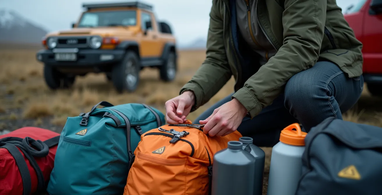
While the geography is different, a safety rule from the Pyrenees mountains offers a life-saving mental model for the extreme unpredictability of the Icelandic highlands: the “15-Minute Rule.” This principle states that weather can change so drastically in 15 minutes that you must pack your gear based on accessibility in a crisis. When a blizzard or storm hits on an isolated F-road, you won’t have time to leisurely unpack your trunk. What you can access in seconds versus minutes could make all the difference.
This packing system forces you to think in terms of emergency response time. For Iceland, this translates to a tiered system of readiness:
- 15 Seconds Access: This is your absolute first line of defense. Your waterproof and windproof shell jacket and pants should be in an easily reachable pocket of your daypack or on the seat next to you, not buried in your luggage.
- 15 Minutes Access: These are your immediate survival items. This includes extra warm layers (fleece, down), high-energy food, a first-aid kit, a headlamp, and a fully charged phone. These should all be in a daypack you can grab instantly.
- 15 Hours Emergency: This is your vehicle’s core survival kit for being stranded. It must contain emergency blankets, at least 4 liters of water per person, power banks, a full spare tire and the tools to change it, and a tow rope.
For the unique challenges of Iceland’s F-roads, this list must be expanded. Always carry extra fuel containers, as gas stations are non-existent in the highlands. Most importantly, since there is often zero cell coverage, a satellite phone or a personal locator beacon (PLB) is a critical piece of communication equipment. It’s your only lifeline if you become stranded or injured.
Why Brittany’s Granite Is Pink and Rare on a Global Scale?
Just as Brittany’s pink granite tells a unique geological story of its formation, the surface of Iceland’s F-roads tells a story of a landscape that is constantly and violently being reshaped. These are not static roads. They are active geological zones characterized by loose volcanic gravel, sharp lava rocks that can shred tires, and steep, unstable inclines. Driving them is an exercise in navigating a terrain that is fundamentally wild and unpredictable.
This dynamic nature is why standard navigation tools like Google Maps or Waze can be dangerously misleading. They operate on data that assumes roads are fixed entities. In the Icelandic highlands, this assumption is false. A road that was passable yesterday could be washed away by a glacial flood (jökulhlaup) overnight. This is why local, real-time information is the only source you can trust. As one F-roads expert warns in a critical safety guide:
A glacial flood can erase a road overnight. This is why you cannot trust Google Maps and must use road.is.
– Iceland F-roads safety expert, F-roads geological hazards guide
The website road.is is the official source from the Icelandic Road and Coastal Administration. It provides up-to-the-minute information on road closures, conditions (e.g., “Impassable”), and specific warnings. Similarly, safetravel.is provides alerts on weather, volcanic activity, and other hazards. Checking these sites should be a non-negotiable ritual every single morning before you turn the ignition key. Trusting these local, expert sources over a generic algorithm is one of the most important safety decisions you will make.
Key Takeaways
- Nature is in charge: F-road safety is about respecting Iceland’s elemental forces—volcanic ash, geothermal heat, and powerful rivers—not just about 4×4 skills.
- Trust local intelligence: Official sites like road.is and safetravel.is are your only reliable sources for real-time road conditions. Google Maps can be dangerously out of date.
- Prepare for the worst: Pack for sudden, violent storms using a timed-access system, and ensure you have specific sand/ash insurance, as standard policies offer no protection.
When to Be in the Forest to See the Light Transform the Landscape?
In the Icelandic highlands, where forests are scarce, the transformative power of light is most critical not for aesthetics, but for safety—especially when crossing rivers. The time of day you choose to ford a river dramatically affects your ability to “read” the water and assess its danger. Attempting a crossing at midday, with the sun directly overhead, can be a mistake. The high-angle light creates glare and makes the water’s surface opaque, hiding the rocks, holes, and true depth of the currents below.
The safest times for river crossings are during the “golden hours” of early morning or late evening. During these periods, the low-angle sunlight works in your favor:
- It reveals texture and ripples on the water’s surface, making it easier to see the direction and speed of the current.
- It creates shadows, which can help you judge the depth of the riverbed and spot large, submerged obstacles.
- It reduces surface glare, allowing for better visibility into the water itself.
A simple rule is to plan your route so that major river crossings are attempted when the sun is low. If you arrive at a significant ford and the sun’s glare prevents you from clearly seeing into the water, the safest decision is to wait. An hour’s delay is infinitely better than a submerged vehicle. This strategic use of light turns a basic natural phenomenon into a powerful risk-assessment tool.
This principle of caution extends to your overall speed. The terrain is treacherous, and visibility can change in an instant. The officially recommended speed on F-roads is generally under 40 km/h (25 mph). This slow pace gives you the reaction time needed to handle the unexpected challenges that the landscape—and the light—may suddenly reveal.
Driving Iceland’s F-roads is a privilege, offering access to some of the most spectacular and raw landscapes on Earth. To do it safely is to enter into a partnership with this environment—one built on respect, preparation, and humility. The ultimate goal is to leave the highlands as pristine as you found them, bringing back only photographs and an unforgettable experience. For a successful journey, the next logical step is to meticulously review your rental agreement for all insurance clauses and cross-reference your planned route with the historical opening dates and conditions on road.is.