To protect Brittany’s fragile coast, a hiker must think like a geologist and act as a conscious steward, as every choice directly impacts the landscape’s future.
- Understand that erosion is accelerated by soil compaction and altered water drainage from foot traffic, not just by storms.
- Select footwear and routes (favouring loops) that minimize soil displacement and distribute human impact.
- Embrace an active role in preservation by reporting damage and making ethically sound decisions, even when taking photos.
Recommendation: On your next hike, consciously analyse the ground beneath your feet and choose the path of least impact, turning your walk into an act of preservation.
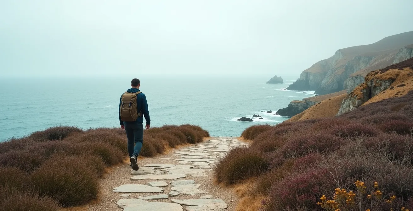
The allure of the Brittany coast is undeniable. With its dramatic cliffs, hidden coves, and the legendary GR34 customs officers’ path winding along the shore, it’s a paradise for walkers. Yet, there’s a growing tension between our desire to experience this raw beauty and the fragile reality of its existence. The very cliffs we admire are crumbling, and the paths we tread contribute to the problem in ways that are far from obvious. Walkers who love these sea views are increasingly concerned, wondering how to enjoy the scenery without becoming part of the problem.
Common advice often feels inadequate. We’re told to “stay on the path” or “be careful,” but these warnings don’t capture the full picture. They don’t explain why one type of rock crumbles faster than another, or how the choice of hiking boots can either preserve a trail or act like a tiny plough, accelerating its demise. The issue isn’t just about avoiding a single catastrophic event; it’s about the cumulative effect of thousands of seemingly insignificant actions by well-meaning visitors. This is a problem that requires more than just following rules; it demands a deeper understanding.
But what if the key to protecting the coastline wasn’t just a set of restrictions, but a new mindset? What if, instead of just being a visitor, you could become an informed guardian of the trail? This guide adopts that unique perspective. We will move beyond the platitudes to explore the ‘why’ behind the ‘how’. By learning to think like a geologist and a land manager, you will understand the subtle forces at play. You’ll discover how every decision, from your footwear to your route planning, is an active vote for either the preservation or the degradation of this magnificent landscape.
This article will guide you through the critical knowledge needed to become a true trail steward. We will delve into the science of erosion, provide practical advice on gear and navigation, and empower you to not only minimize your impact but also contribute positively to the conservation of Brittany’s coastal path.
Summary: A Hiker’s Guide to Preserving the Brittany Coast
- Why Do Cliff Edges Collapse Even Without Heavy Rain?
- How to Choose Shoes for Trails That Mix Sand, Mud, and Rock?
- Loop Circuits or Linear Walks: Which Is Easier for Solo Coastal Hikers?
- The Tide Calculation Error That Traps Hikers on Beach Sections
- How to Report a Dangerous Section of the Coastal Path to Authorities?
- How to Hike the GR34 Custom Officers’ Path Without Contributing to Erosion?
- Why Does Limestone Crumble Faster Under Human Traffic Than Granite?
- How to Photograph the Pink Granite Coast Without Trampling Protected Heathland?
Why Do Cliff Edges Collapse Even Without Heavy Rain?
The common image of coastal erosion is a dramatic winter storm, with massive waves crashing against cliffs and washing away tonnes of rock. While accurate, this picture is dangerously incomplete. Many subsidences and collapses along the Brittany coast occur during seemingly calm weather, a phenomenon that points to a more insidious cause: hydrological stress exacerbated by human foot traffic. When hikers repeatedly walk over the same patch of ground, the soil becomes compacted. This seemingly minor change has major consequences.
Compacted soil loses its ability to absorb water. Instead of percolating gently downwards, rainwater runs off the surface, seeking the path of least resistance—often towards the cliff edge. This surface runoff concentrates into small channels, gaining momentum and stripping away topsoil and vegetation that act as a natural binder. Furthermore, the ground beneath the compacted surface can become saturated, increasing its weight and pore pressure, which dramatically reduces its structural integrity. It’s a slow, cumulative process where thousands of footsteps prepare the ground for failure, long before a final trigger like a light rain or even just gravity takes its toll.
This is not a theoretical danger. Along many sections of the Brittany coast, local authorities have posted warning signs about these very risks. The case of the GR34 is a clear example, where tourist office websites frequently describe parts of the path as dangerous due to the “risk of subsidence.” These warnings highlight that the cliff is a living, moving entity. The cumulative micro-impacts from hikers can be the tipping point that turns a stable-looking edge into a hazard zone, demonstrating that erosion is a constant process, not just a seasonal event.
How to Choose Shoes for Trails That Mix Sand, Mud, and Rock?
Choosing footwear for the GR34 often focuses on comfort and grip, but a preservation-focused hiker must also consider a shoe’s impact on the trail itself. The mixed terrain of sand, mud, and rock demands versatility, but it also presents an opportunity to practice footprint-discipline. The key is to match the sole of your shoe to the fragility of the surface, and often, less is more. Highly aggressive, deep lugs are excellent for digging into deep mud, but on softer ground like sand or the delicate heathland soil, they act like small ploughs, churning the surface and displacing far more material than necessary.
The ideal shoe for a conscious hiker on a mixed coastal trail features a moderately-lugged sole. This design provides sufficient grip on slippery rocks and muddy patches without being overly destructive on more sensitive surfaces. Look for soles with a larger surface area and shallower, multi-directional patterns. These designs distribute your weight more evenly and shear less soil with each step. On sandy sections, a less aggressive tread prevents you from digging in and kicking back loose sand, which is then more easily carried away by wind and water. It’s a subtle shift from choosing a shoe that conquers the terrain to one that respects it.
This choice directly influences the rate of trail widening and soil loss. An aggressive tread on a dry, peaty path can tear up the surface, exposing it to erosion. The visual below illustrates how different sole patterns leave distinct imprints, each representing a different level of ground disturbance. By selecting a shoe with a balanced tread, you are making a conscious decision to minimize your personal contribution to trail degradation, ensuring the path remains stable and usable for years to come.
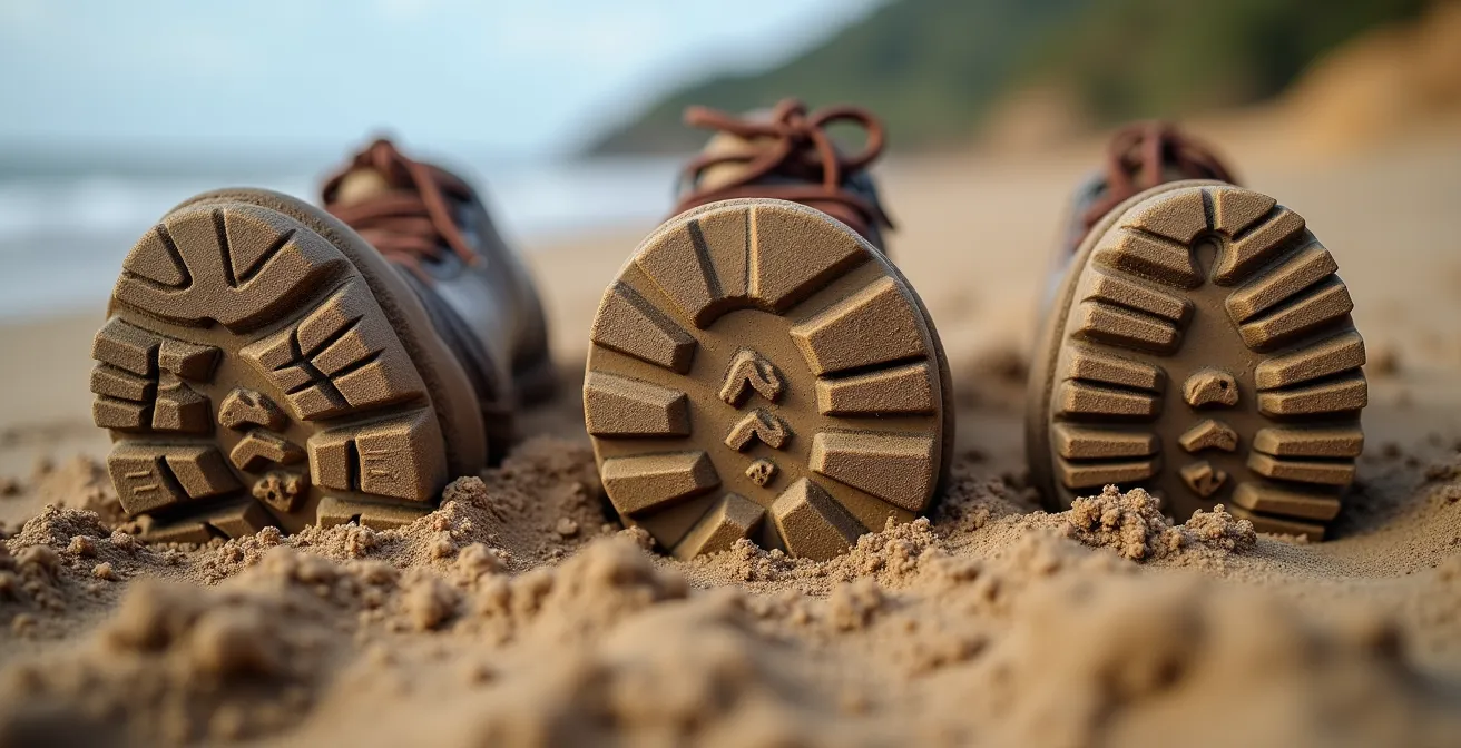
As the image demonstrates, the imprint left behind is a direct measure of your impact. A more moderate sole leaves a cleaner, less disruptive footprint, which is the essence of sustainable hiking. This approach ensures your safety and comfort without sacrificing the health of the very environment you’ve come to enjoy.
Loop Circuits or Linear Walks: Which Is Easier for Solo Coastal Hikers?
For a solo hiker, the logistics of a linear walk can be daunting, often requiring two cars or reliance on sparse rural bus services. From this practical standpoint, loop circuits are almost always easier. They allow you to start and finish in the same place, eliminating transport headaches. However, the benefits of choosing a loop go far beyond personal convenience; it is a powerful act of trail-stewardship that helps mitigate a major cause of erosion: concentrated foot traffic.
Linear “out-and-back” walks, especially on the most famous stretches of the GR34, double the impact on a single section of trail. Popular trailheads and access points become “sacrifice zones,” where the path is unnaturally wide, compacted, and stripped of vegetation due to the sheer volume of people starting their journey. By opting for a loop, you help distribute this pressure across a wider network of paths. Research on Brittany’s coastal trails shows that many popular hikes can be easily converted into loops, often with less than an hour of additional walking on quiet lanes or other footpaths, a small price to pay for a significant environmental benefit.
This strategy of dispersal is crucial when you consider the immense cost of managing erosion. While figures for Brittany are specific, the scale of the problem is global; for example, a 2013 report noted that coastal erosion costs the United States approximately $500 million annually in property loss and mitigation. By choosing routes that spread out the load, hikers can actively reduce the wear and tear that leads to these costly and damaging consequences. A loop walk is therefore not just a smart logistical choice; it’s a strategic decision to reduce your share of the cumulative micro-impacts on the most fragile and popular parts of the coast.
The Tide Calculation Error That Traps Hikers on Beach Sections
The tides in Brittany are among the most dramatic in Europe. The massive tidal swing can transform the landscape in a matter of hours, revealing vast beaches that completely disappear a short time later. For hikers, this presents both an opportunity and a significant danger. A common and perilous error is miscalculating the tide, leading to being trapped on a beach section with a rising sea and no safe exit. This is not only a life-threatening situation but also one that often results in severe, localized environmental damage.
When faced with a rising tide, a trapped hiker’s only option is often to scramble up the nearest cliff or dune system. These are invariably the most fragile and unstable parts of the coastline. A desperate climb can dislodge tonnes of loose material, destroy years of delicate vegetation growth that holds the dune together, and create deep scars that will be rapidly enlarged by wind and rain. Therefore, meticulous tide planning is a cornerstone of both personal safety and environmental responsibility. It’s an act of preservation as much as self-preservation.
Relying on a general tide time for a major port is not enough. The complex geography of coves and headlands means that local times can vary significantly. Hikers must use tide charts specific to their exact location and always build in a generous buffer, especially during spring tides when the range is greatest. A rising tide moves much faster across a flat beach than you might expect. Adhering to a strict safety protocol is the only way to ensure you don’t have to make a choice that compromises your safety or the integrity of the coastline.
Your Essential Tide-Safety Checklist for Coastal Hiking
- Understand the Swing: Acknowledge the huge tidal range in Brittany, where entire beaches appear and disappear daily.
- Account for the Zone: Be aware that the intertidal zones can extend several hundred meters from shore, requiring significant time to cross.
- Get Local Charts: Always check tide charts specific to your exact hiking location, not just the nearest large town or port.
- Build a Buffer: Allow significant extra time for any beach crossing, particularly during the powerful spring and autumn tides.
- Check Your Escape: Never start a beach walk on a rising tide unless you have a confirmed, safe, and accessible exit route visible ahead.
How to Report a Dangerous Section of the Coastal Path to Authorities?
With its immense popularity, the GR34 is under constant pressure. In 2018, it was estimated that the trail was used by 9 million users, generating significant local economic benefits but also placing a tremendous strain on the physical infrastructure of the path. No single organization can monitor every meter of this extensive network in real-time. This is where the individual hiker’s role as a steward becomes critically important. Reporting a dangerous or newly eroded section is one of the most impactful actions you can take.
Observing a fresh landslide, a dangerously undercut path, or a broken stile and reporting it is not someone else’s job—it’s a collective responsibility. This feedback is invaluable for the volunteer-based organizations that work tirelessly to maintain the trails. In France, the primary body responsible for the maintenance of GR® (Grande Randonnée) trails is the Fédération Française de la Randonnée Pédestre (FFRandonnée). This federation and its regional committees rely on thousands of volunteer markers and donations to carry out their work.
So, how do you report an issue? The most effective method is to be specific. Note the exact location, using a GPS coordinate from your phone or a detailed description with reference to nearby landmarks (e.g., “500 meters west of the Pointe de Primel, the path has collapsed”). Take photos if possible. The report can typically be made to the local Tourist Office (Office de Tourisme) or the Mairie (town hall) of the commune where the issue is located. They act as the local liaison with the FFRandonnée or the departmental services responsible for the coastline. By taking a few minutes to make a report, you transform your hike from a passive activity into an active contribution to the safety and sustainability of the trail for the millions who will follow you.
How to Hike the GR34 Custom Officers’ Path Without Contributing to Erosion?
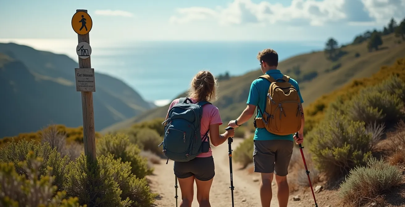
Hiking the GR34 without contributing to erosion is an exercise in conscious decision-making, transforming the simple act of walking into a practice of footprint-discipline. It begins with the fundamental commitment to stay strictly on the marked trail. Every time a hiker cuts a corner or creates a “desire line,” they trample vegetation and compact new soil. This small shortcut, when multiplied by thousands, becomes a new channel for water, a new point of failure, and widens the scar on the landscape.
Beyond this golden rule, other practices significantly reduce your impact. If you use trekking poles, fitting them with rubber tips is essential on soft or muddy ground. The sharp carbide tips, designed for ice or hard rock, churn up soil and damage plant roots, while rubber tips provide grip with minimal disturbance. This small adjustment is a perfect example of a micro-action with a large cumulative benefit. The illustration below captures the essence of this choice, where hikers are seen actively engaging with their gear and the marked path, a clear sign of responsible hiking.
Supporting the trail’s upkeep is another powerful tool. The FFRandonnée, the organization that maintains these paths, is heavily reliant on volunteers and financial support. Making a donation is a direct investment in the trail’s future, funding the very materials and labour needed to repair eroded sections and reroute paths away from danger. Finally, carrying essential personal items like water and sun cream prevents the need to leave the trail in search of resources, reducing unplanned impacts. By combining these practices, you move from being a mere user of the path to an active and effective steward of its future.
Why Does Limestone Crumble Faster Under Human Traffic Than Granite?
To walk the Brittany coast with a preservationist mindset is to develop a sense of geological empathy. A key part of this is understanding that not all rock is created equal. The dramatic difference in erosion rates between sections of the coast can often be explained by the underlying geology: primarily the distinction between hard, crystalline granite and softer, sedimentary limestone. Granite, which forms the iconic Pink Granite Coast, is an igneous rock, forged from cooled magma. Its interlocking crystal structure makes it incredibly hard and resistant to both physical and chemical weathering.
Limestone, found in other coastal areas, has a vastly different origin and structure. It is a sedimentary rock, typically formed from the compressed skeletal fragments of marine organisms like coral and shells. Its primary component, calcium carbonate, is much softer than the quartz and feldspar found in granite. More importantly, it is chemically vulnerable. Rainwater is naturally slightly acidic, and this acid reacts with the calcium carbonate, slowly dissolving the rock. The pressure from a hiker’s boot can crush the porous structure, creating micro-fractures that allow more water to penetrate, accelerating this process of chemical decay from the inside out.
This fundamental difference explains why limestone cliffs can seem to crumble and shale, while granite headlands are worn smooth over millennia. As a general scientific principle, the forces at play are universal. As noted by researchers, “Coastal erosion involves the breaking down and removal of material along a coastline by the forces of wind, waves, and longshore currents.” The rate at which this happens is dictated by the rock’s inherent resilience.
Coastal erosion involves the breaking down and removal of material along a coastline by the forces of wind, waves, and longshore currents. Rates of coastal erosion can be affected by human activity, sea level rise, seasonal fluctuations, and climate change.
– Schwab et al., ScienceDirect Coastal Erosion Overview
Understanding this distinction allows a hiker to adjust their level of caution. When the path crosses over softer, lighter-coloured sedimentary rock, you know that every footstep has a disproportionately larger impact than on a solid granite outcrop. This knowledge is the foundation of true footprint-discipline.
Key Takeaways
- Practice Geological Empathy: Understand the difference between granite and limestone to recognize fragile zones and adapt your behaviour accordingly.
- Master Footprint-Discipline: Make conscious choices about your gear (e.g., shoe soles) and your route (e.g., loops over linear) to minimize soil displacement and trail wear.
- Become a Trail Steward: Move beyond a passive role by actively reporting damage and supporting the organizations that maintain the paths.
How to Photograph the Pink Granite Coast Without Trampling Protected Heathland?
The Pink Granite Coast is arguably the crown jewel of the GR34, with the stretch around Ploumanac’h offering otherworldly rock formations sculpted by millennia of erosion. It is a magnet for photographers, both amateur and professional. Yet, the desire for the perfect shot creates a specific and acute conservation challenge: the trampling of protected coastal heathland. This low-growing, hardy vegetation is not just a pretty backdrop; it’s a vital ecosystem that stabilizes the thin topsoil on the cliffs. Its root systems form a natural net that holds the ground together against wind and rain.
When a photographer steps off the marked path to get a slightly better angle, they crush this delicate vegetation. A single footstep might not seem like much, but these areas are often targeted repeatedly. The result is a network of unofficial trails, bare patches of exposed soil, and compacted ground that can no longer absorb water. This directly accelerates the very erosion photographers come to document. The irony is tragic: in the quest to capture beauty, the foundations of that beauty are destroyed. The consequences are severe, with studies on other coastlines showing that average coastline recession rates of 25 feet per year can occur on vulnerable islands, highlighting the potential speed of landscape loss when stabilizing elements are removed.
Practicing photographic footprint-discipline means accepting that the best photo is one taken ethically. This involves using a longer lens from the designated path rather than walking to the subject, respecting all barriers and signs, and recognizing that no picture is worth damaging a fragile environment. At sites like Île Renote near Trégastel, the official paths have been carefully designed to offer breathtaking views of the coast and the Seven Islands archipelago without requiring visitors to leave them. The challenge for the responsible photographer is to work within these constraints, using creativity and composition to capture the magic of the Pink Granite Coast without leaving a scar.
The next logical step for any walker inspired to protect this landscape is to adopt this stewardship mindset on every future hike. Begin today by planning your next coastal walk not just by its length or difficulty, but by its potential for positive impact.