Choosing between Milford and Doubtful Sound isn’t about which is prettier; it’s a tactical decision about your tolerance for logistical challenges and environmental hostility.
- Milford offers dramatic, accessible beauty but demands you contend with crowds and a hazardous access road.
- Doubtful provides profound solitude and scale, but at a higher cost and with more complex, multi-stage travel.
Recommendation: Base your choice not on Instagram photos, but on an honest assessment of your skills, preparedness, and desire for genuine isolation. This guide provides the operational intelligence to make that call.
The typical travel guide pits Milford Sound against Doubtful Sound in a simple beauty contest. Milford is the dramatic, world-famous icon; Doubtful, the vast, silent giant. This framing is a disservice. It misses the fundamental point of Fiordland: this is not a theme park. It’s one of the planet’s most formidable and hostile natural environments, and your experience is defined not by what you see, but by how you manage the conditions. The real choice is about operational readiness. Are you prepared for the relentless rain, the swarming sandflies, the logistical hurdles of securing a spot on a sold-out track, and the sheer unpredictability of the weather?
Forget the simple pros and cons. The core question is one of commitment. Milford’s accessibility is its greatest asset and its biggest liability, concentrating crowds and traffic on a single, dangerous road. Doubtful’s remoteness guarantees solitude but requires a multi-layered journey—a boat, then a bus, then another boat—that filters out all but the most determined. This guide is built on a different premise: that the best experience comes from understanding the systems at play. We’ll dissect the environment, from the geology that creates its dangers to the weather patterns you must learn to read. We’ll give you the tactical knowledge to pack, plan, and execute a trip that respects the raw power of this place.
This is not about picking a winner. It’s about deciding which set of challenges you are willing and equipped to face. By the end of this article, you will have the intelligence to look past the postcards and choose the fjord that aligns with your capacity for true adventure.
This article provides a complete operational framework for your Fiordland decision. We will explore the unique environment, the tactical choices you’ll face, and the essential preparations for managing one of the world’s wildest places. The following sections break down everything you need to know.
Summary: A Tactical Guide to Choosing Your Fiordland Experience
- Why Does Fiordland Look Better in the Rain Than in the Sun?
- Big Cruise or Kayak: Which Gets You Closer to the Waterfalls?
- The Sandfly Mistake That Will Ruin Your Fiordland Hike
- When to Log In to Book the Milford Track Before It Sells Out?
- How Did Ice Carve U-Shaped Valleys into Granite?
- How to Interpret Cloud Formations to Predict Sudden Squalls?
- How to Pack for a Multi-Day Hike Where Refuges Are the Only Option?
- How to Drive Safely on Iceland’s F-Roads for Beginners?
Why Does Fiordland Look Better in the Rain Than in the Sun?
For most destinations, rain is a deal-breaker. In Fiordland, it’s the main event. A sunny day is pleasant, but it reveals only a fraction of the landscape’s character. The true spectacle begins when the clouds descend and the water flows. With an annual rainfall that can exceed 7 metres of rain per year, this region is designed for wet weather. The steep granite walls, which feature only a handful of permanent waterfalls on a dry day, come alive with hundreds, sometimes thousands, of temporary cascades during a downpour. The entire landscape weeps, transforming into a dynamic, roaring spectacle.
The rain is not just an aesthetic amplifier; it is the architect of a unique ecosystem. The immense freshwater runoff, stained dark brown by tannins from the forest floor, sits on top of the heavier saltwater of the fjords. This “dark-lense effect” creates a unique phenomenon detailed by experts: it blocks sunlight so effectively that deep-sea species like rare black coral can be found at incredibly shallow depths of just 10 meters, a sight normally reserved for technical divers below 40 meters. The rain, therefore, creates an entirely different world just beneath the surface.
For photographers, overcast, rainy conditions are a gift. The soft, diffused light eliminates the harsh shadows and blown-out highlights common on a sunny day, allowing you to capture the dramatic textures of the wet, dark granite. Mist and low-hanging clouds add layers and depth to your compositions, creating an atmosphere of primeval mystery. Embracing the rain isn’t just a coping mechanism; it’s a strategic decision to witness Fiordland at its most powerful and authentic.
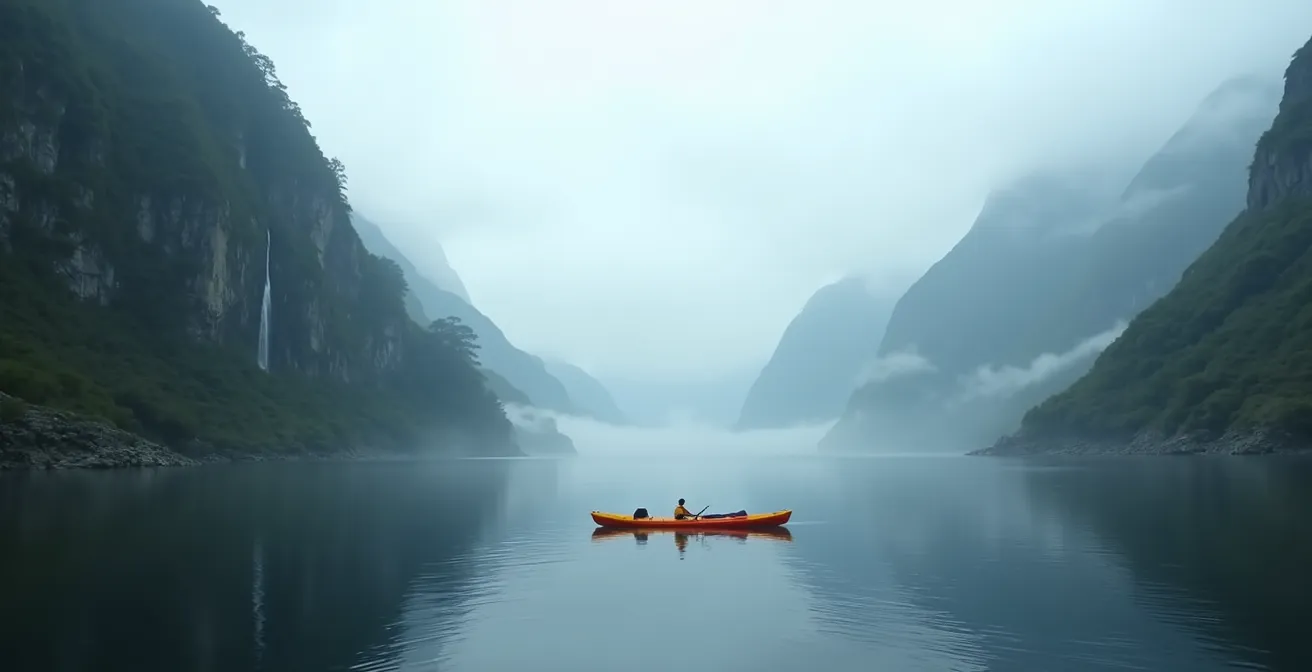
Big Cruise or Kayak: Which Gets You Closer to the Waterfalls?
Your choice of vessel is a critical tactical compromise between scale, intimacy, and risk. The large cruise ships that dominate Milford and Doubtful Sounds offer a stable, comfortable, and elevated platform. They can get impressively close to the major waterfalls, nosing the bow into the spray, but the experience is mediated by the hum of engines and the voice over the PA system. Kayaking, by contrast, is a full-sensory immersion. It puts you at water level, where the scale of the granite cliffs feels truly immense. You can paddle directly under the spray of a waterfall, feeling its power and hearing nothing but the sound of water and your own paddle.
As one Local Fiordland Guide from the Fiordland Outdoors Company points out, the auditory experience is fundamentally different:
The auditory footprint matters – when you’re on a kayak, you hear the silence between paddle strokes. On a cruise, there’s always that background hum of engines and commentary.
– Local Fiordland Guide, Fiordland Outdoors Company
This choice, however, is not just about preference. It’s about risk management. The stability of a large cruise ship makes it a low-risk activity that operates in most weather. Kayaking is a high-risk endeavor. You are completely exposed to the elements, especially the fierce katabatic winds that can funnel down the valleys without warning. A calm morning can turn into a treacherous struggle against high winds and chop in minutes. Kayak trips are frequently cancelled due to weather, requiring flexibility in your plans. The following table breaks down the core trade-offs.
| Experience Factor | Large Cruise | Kayaking |
|---|---|---|
| Distance from Waterfalls | 10-20 meters (boat can get close) | Can paddle directly under spray |
| Sound Experience | Engine noise, PA announcements | Natural sounds, paddle dips |
| Risk Level | Low – stable platform | High – exposed to katabatic winds |
| Wildlife Viewing | Elevated deck view | Water-level perspective |
| Duration | 2 hours typical | 3-4 hours minimum |
| Weather Dependency | Operates in most conditions | Cancelled in high winds/storms |
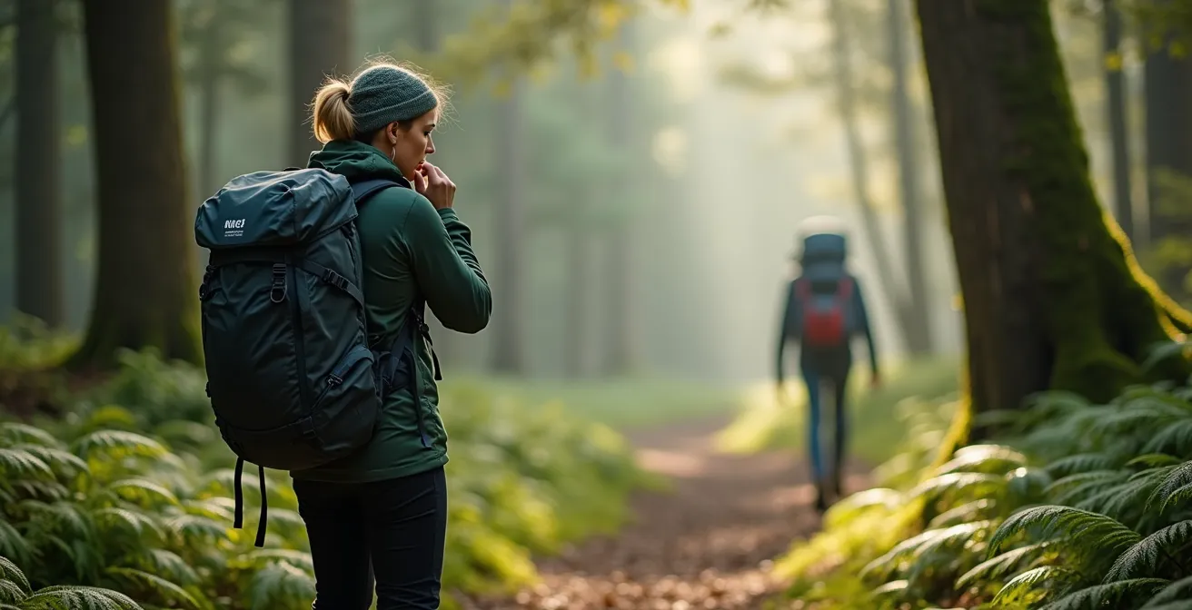
The Sandfly Mistake That Will Ruin Your Fiordland Hike
Underestimate the New Zealand sandfly (te namu) at your peril. These tiny, biting insects are not a minor annoyance; they are a form of environmental hostility that can mentally break the unprepared. In peak conditions, particularly near water sources at dawn and dusk, the onslaught is relentless. Forget pleasant trailside breaks; the moment you stop moving, you are the target. While exact numbers vary, some studies have shown that in peak activity, sandflies can inflict up to 1,000 bites per hour. This is not an exaggeration. The primary mistake visitors make is treating them like common mosquitoes. They are far more persistent and their bites can be intensely itchy for days.
Standard insect repellent is often insufficient. Your defense must be a multi-layered system. The biggest error is waiting until you feel the first bite to apply repellent. You must prepare before exiting your vehicle or hut. Long sleeves and pants are mandatory, but sandflies can and will bite through common stretch-fit activewear. Tightly woven fabrics are your best defense. For multi-day hikes, permethrin-treated clothing and a head net are not luxuries; they are essential pieces of survival equipment. The head net, in particular, offers crucial mental relief when you need to stop.
Effective sandfly management is about tactical behavior, not just chemicals. Setting up camp, cooking, or taking a rest should be done away from the immediate vicinity of streams or lake shores. Understanding their activity windows—dawn and dusk—allows you to plan your movements and minimize exposure during their peak feeding times. Adopting a proper protection strategy is non-negotiable for anyone wanting to hike or camp in Fiordland without their trip being ruined.
Your Action Plan: Sandfly Defense Protocol
- Apply a DEET-based repellent BEFORE you get out of your car or leave the hut. The attack is immediate.
- Wear long, light-colored, and tightly woven clothing. They can bite through merino and yoga pants.
- For multi-day trips, invest in permethrin-treated clothing and carry a head net. This is your sanity-saver.
- Time your stops and camp setup to avoid peak activity at dawn and dusk. Move quickly during these windows.
- When taking a break on the trail, move at least 10-20 meters away from still or slow-moving water sources.
When to Log In to Book the Milford Track Before It Sells Out?
If you plan to hike the Milford Track, one of New Zealand’s premier Great Walks, your battle begins months before you set foot in Fiordland. Competition for hut tickets is ferocious. The Department of Conservation (DOC) releases tickets for the entire season on a single day, typically in late autumn (April/May). The entire season’s worth of bunks can be gone in minutes. Last year, the official booking site crashed under the demand, and reports showed the Milford Track was fully booked in under 3 minutes. This is not a casual booking process; it requires military-style coordination.
Success depends on preparation and speed. You must have your DOC account created and all your group members’ details pre-loaded well in advance. On booking day, you need to be logged into the booking lobby at exactly 9:00 AM New Zealand Standard Time (NZST) to be assigned a random spot in the virtual queue. Having multiple date scenarios and even backup track options is crucial, as your first choice will likely be gone by the time it’s your turn. Coordinating with your group using multiple devices can increase your chances. For those who miss out, a small number of spots often become available again around 10:00 AM as incomplete or failed bookings are released back into the system.
For solitude seekers who fail to secure a Milford spot, this can be a blessing in disguise. It forces you to consider excellent, less-trafficked alternatives that offer a more remote experience. The Hollyford Track, for instance, provides a stunning 56km journey from the mountains to the rugged Tasman Sea coast. Unlike the rigid booking and 40-bunk limits of Milford, parts of the Hollyford operate on a first-come, first-served basis outside the peak guided season, offering the kind of genuine solitude that the crowded Milford Track often lacks. This logistical challenge filters for determination, often rewarding those who are flexible with a more profound wilderness encounter.
How Did Ice Carve U-Shaped Valleys into Granite?
The epic grandeur of Fiordland was sculpted by ice. During successive ice ages, massive glaciers, thousands of feet thick, flowed from the mountains toward the sea. These rivers of ice were powerful erosive forces. Unlike rivers, which carve V-shaped valleys, glaciers pluck and grind away at the entire valley floor and its sides, gouging out the landscape’s characteristic deep, steep-sided, and flat-bottomed U-shaped valleys. The sheer granite walls of Milford and Doubtful Sounds are a direct result of this immense glacial scouring action. When the glaciers retreated and sea levels rose, the ocean flooded these carved-out troughs, creating the fjords we see today.
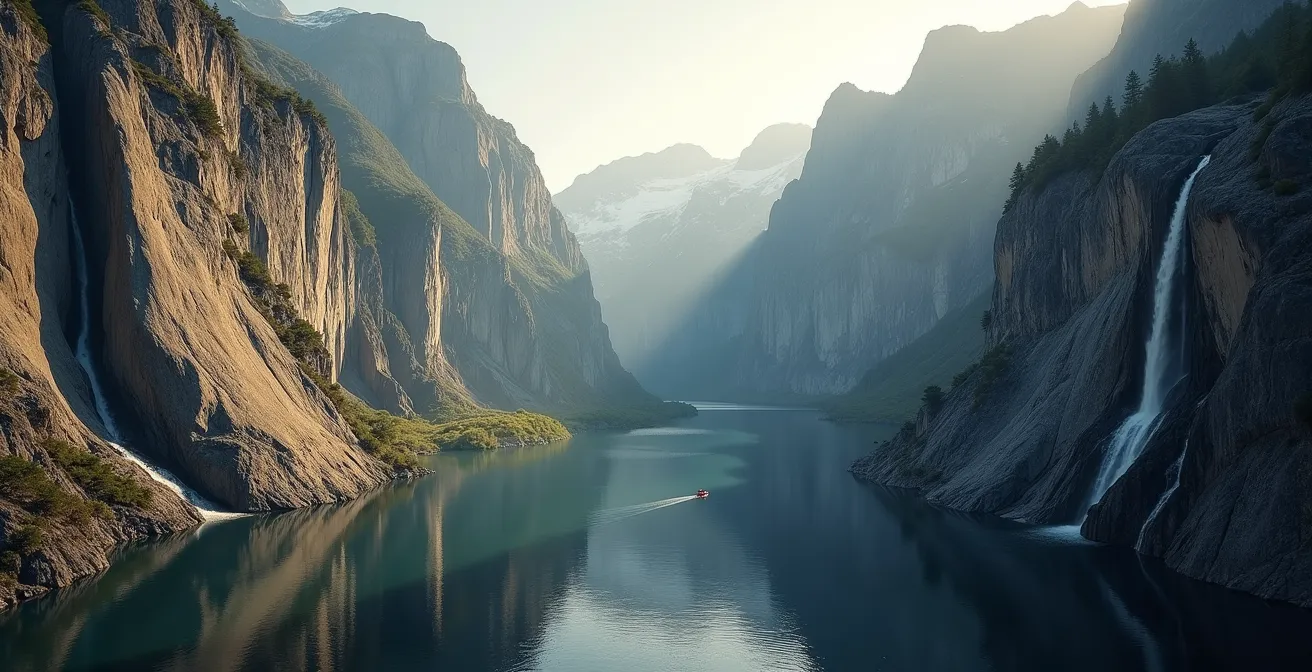
Understanding this geology is not just an academic exercise; it’s a matter of survival. The very features that make the landscape so dramatic also create specific and deadly hazards. The smooth, U-shaped profile of the valleys acts as a perfect funnel for wind. Katabatic winds—cold, dense air accelerating down slopes—can plummet into the fjords, reaching hurricane force with little to no warning. These winds are a major threat to kayakers and small boats.
Furthermore, the sheer, non-porous granite walls offer no escape routes or safe harbors during a storm. They also create a high risk of flash floods. Hanging valleys, smaller tributary valleys left “hanging” high above the main fjord floor, can collect immense amounts of rainwater during a deluge. This water can then cascade into the main valley in a torrent, causing water levels to rise with terrifying speed. The geological beauty of Fiordland is inextricably linked to its inherent dangers. Recognizing that the U-shaped valley is a wind funnel and a flood channel is the first step in risk assessment for any activity in the fjords.
How to Interpret Cloud Formations to Predict Sudden Squalls?
In Fiordland, the official weather forecast is often a vague and unreliable guide. The region’s complex topography creates countless microclimates where conditions can change with shocking speed. Your best tool for predicting sudden, violent squalls is not your phone; it’s your eyes. Learning to read the clouds is a critical survival skill, providing more accurate, real-time warnings than any meteorological service.
The most important indicator to watch for is cloud layers moving in different directions at different altitudes. This signifies significant atmospheric instability and is a strong predictor of imminent, unpredictable weather. Another key formation to identify are lenticular clouds, the smooth, lens-shaped clouds that often form over mountain peaks. While beautiful, they are a clear warning of severe turbulence and powerful downslope winds that can wreak havoc in the valleys below.
However, the most famous and reliable local storm predictor is a formation known as the Nor’west arch. This is a distinctive arc of high, white cloud that appears in the sky to the northwest, over the main mountain divide. Local guides and seasoned trampers swear by it as Fiordland’s most accurate warning system. Its appearance signals the approach of a frontal system, typically bringing strong winds and heavy rain within 6 to 12 hours. Learning to spot this arch gives you a crucial window to change plans, seek shelter, or secure your camp before the storm hits. In an environment this volatile, the sky is your most honest forecaster.
Key takeaways
- Fiordland’s defining feature is its hostile weather; embracing the rain and preparing for it is essential.
- The choice between a cruise and a kayak is a tactical trade-off between comfort, risk, and immersion.
- A multi-layered defense strategy against sandflies and a coordinated booking plan for Great Walks are non-negotiable preparations.
How to Pack for a Multi-Day Hike Where Refuges Are the Only Option?
Packing for a multi-day hike in Fiordland, where you’ll be relying on the basic DOC hut system, is an exercise in ruthless efficiency and redundancy. With approximately 200 rainy days per year, you must operate under the assumption that everything will get wet. Your survival depends on keeping a few key items absolutely dry. This is where the principle of system redundancy becomes paramount. A single pack cover is not enough.
The gold standard is a triple-layered waterproof system: a heavy-duty pack liner inside your backpack, individual dry bags for critical items within the liner, and a rain cover on the outside of your pack. Within this system, you must enforce strict discipline with a “two-bag” mentality. One set of gear is your “wet gear”—the clothes you hike in, which will inevitably be damp. The second is your “sacred dry bag,” which contains your sleeping bag, a dry set of clothes for the hut, and your fire-starting equipment. This bag is never opened outside the shelter of a hut.
Redundancy should apply to all critical systems. Carry two lighters in separate dry bags. Have a physical, waterproof map and compass as a backup to any GPS device, as batteries fail and electronics are vulnerable to moisture. One often-overlooked item is a lightweight fly screen or bug net for your bunk. While huts offer shelter, they are not immune to sandfly infiltration, especially when people are entering and exiting. Practicing an “airlock” entry technique—removing your wet gear and pack outside before quickly entering and closing the door—helps minimize the number of sandflies you bring into the shared living space.
How to Drive Safely on Iceland’s F-Roads for Beginners?
While you’re thousands of miles from the volcanic highlands of Iceland, the mindset required to drive its treacherous F-Roads is precisely what you need to tackle New Zealand’s State Highway 94, the Milford Road. The name on the map is different, but the risks—and the absolute need for preparedness—are identical. The Milford Road may be sealed, but it is widely considered New Zealand’s most dangerous tourist drive, a 120km stretch of road with no fuel, no cell service, and a host of unique, potentially lethal hazards.
The drive from Te Anau to Milford Sound traverses multiple active avalanche zones and rockfall areas, marked by stark “No Stopping” signs that must be obeyed without question. The road’s climax is the Homer Tunnel, a 1.2km long, unlit, one-way passage drilled through solid granite on a steep downward grade. In winter, carrying snow chains is mandatory, and the road can close for days without warning due to snow or avalanche risk, potentially trapping visitors in Milford. You must be self-sufficient.
Driving this road requires a shift from a tourist mindset to an expeditionary one. Before you even turn the key, you must check the Waka Kotahi (NZTA) road status. Your vehicle must be filled with fuel in Te Anau. You need to carry emergency supplies, including enough food and water for 48 hours, as well as warm clothing, even on a summer day. You should allow a minimum of 2.5 hours for the drive one-way, not including stops. This is not a commute; it is a journey through a hazardous environment where your safety is your own responsibility.
The real choice isn’t between Milford or Doubtful; it’s an honest assessment of your own preparedness. Your next step is not to book a tour, but to evaluate your gear, your skills, and your tolerance for the beautiful, unforgiving wilderness of Fiordland.